Typology 1: Neighborhood Greenspaces
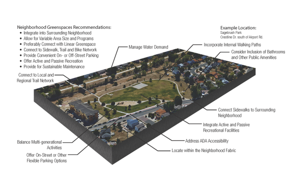
The goal of this landscape typology is to strengthen partnerships and resources available to provide smaller and more localized park and recreation facilities within neighborhoods.
This typology includes neighborhood parks, mini parks, pocket parks, medians, parkways, rights-of-way, trails, linear parks, playgrounds, and other facilities with various sizes and programs. In some areas of the city, these can include shared facilities, or facilities owned and managed by non-city entities such as school districts, metropolitan districts, or homeowners associations, as long as they are reasonably open or available to the public. These areas should be conveniently located to serve their immediate neighborhoods and contribute to the fabric of these local communities. Independent of size, they should be activated with recreation and leisure opportunities, and should serve as a common area for neighbors of all ages to gather, socialize, and play. Neighborhood Greenspaces should be accessible within walking distance and connected to the neighborhood by pedestrian trails and sidewalks. With the City requiring major annexors and new developments to construct and maintain their dedicated neighborhood park land, special districts including metropolitan districts play a significant role in the ownership and maintenance of these areas.
- Examples: Ford Frick, Mountain Shadows, Nancy Lewis, Thorndale, Sagebrush, and Village Green Parks.
Typology 2: Sports and Recreation
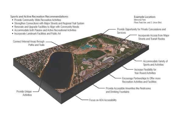
The goal of this landscape typology is to provide opportunities and flexible facilities that accommodate a range of active and passive recreation activities.
This typology includes community parks, sports complexes, golf courses, and other active recreation facilities. These areas serve as focal points for community-wide recreation activities. The larger areas that these facilities cover offer diverse opportunities for programmed sports and other community activities such as gardens and picnic areas. Sports and Active Recreation areas should preferably have good access from major streets and direct access to the regional trail system. Community parks provide active recreational facilities such as athletic fields, community recreation buildings, and/or other special features that cannot be easily accommodated in neighborhood parks. In addition to furnishing facilities for programmed activities, Sports and Active Recreation areas may also provide large areas for open play, walking, and other non-programmed uses.
- Examples: Memorial Park, Coleman Park, Rampart Park, Sky View Sports Complex, El Pomar Youth Sports Complex, Monument Valley Park, Quail Lake Park, Valley Hi Golf Course, Patty Jewett Golf Course, and Pine Creek Golf Course.
Typology 3: Natural Resources and Regional Recreation
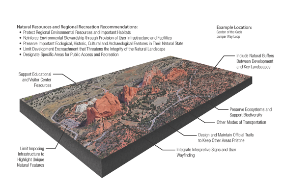
The goal of this landscape typology is to balance tourism, recreation use, and environmental protection of important natural resource areas that embody the majestic scenery of Colorado Springs.
This typology includes regional parks and open space areas, including many federal, state, and county parks and open space areas, along with City-managed open space resources. These are large protected areas with regionally significant natural resources, often functioning as major natural area or regional landmarks. This typology focuses on nature-oriented, passive outdoor recreation, with an emphasis on appropriate balance between resource protection and public use. Additionally, open space areas set aside land to retain ecological, historic, cultural, archeological, and aesthetic features in their natural state. Many of these areas attract a significant number of tourists as well as local users. The environmental benefits include providing wildlife habitat, preserving fragile ecosystems, supporting biodiversity, and protecting ground water and surface water quality. These natural areas create a buffer around urban areas, generally considered the Wildland Urban Interface (WUI), and are particularly at risk to natural hazards. This system of open spaces and natural areas is essential to the PlanCOS vision of protecting its scenic and natural landscapes.
- Examples: Garden of the Gods, Palmer Park, North Cheyenne Cañon Park, Red Rock Canyon, Stratton Open Space, Corral Bluffs Open Space, Jimmy Camp Creek Park, and Austin Bluffs Open Space.
Typology 4: Community Education Landscapes
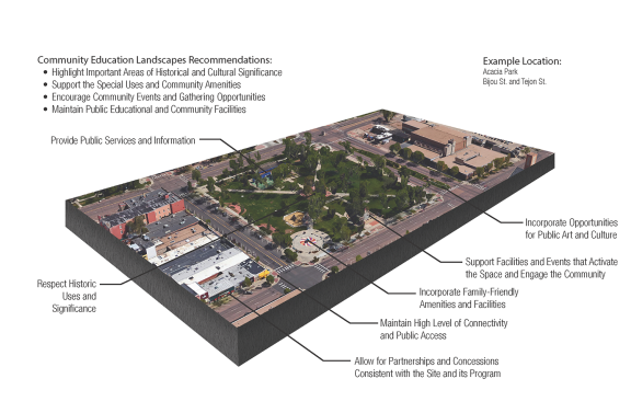
The goal of this landscape typology is to reinforce the city’s culture and history within public educational and community facilities.
This typology includes urban plazas, areas that have special historical community significance, visitor and environmental centers, and cemeteries. Many of these facilities are located in the Downtown core of Colorado Springs. These facilities serve a particular community need, such as a horticultural center, environmental education center, working farm, performance area, urban plaza, civic park, or burial ground.
- Examples: Acacia Square, Alamo Square, Bancroft Park, City Hall Park, Antlers Park, Starsmore Visitor and Nature Center, Rock Ledge Ranch, Evergreen, and Fairview Cemeteries.
Typology 5: Greenways
This typology includes natural, landscaped, and stream corridors that connect parks and natural areas. Often these links include off-street trails and connectors, but some may only serve as open space and wildlife links. The city encompasses several hundred miles of streams and drainageways. Many streams are hidden from view and may or may not be used by the public. Since many of these streams are unlikely to change in their use or in their need for more multi-purpose accommodations, PlanCOS primarily focuses on effecting change along streams with a large enough corridor for recreational or improvements. Furthermore, due to their locations, conditions, and current use, some streams are more difficult to categorize, and may change from one typology category to another as they travel through the city.
These typologies emphasize balancing linear recreation with natural resource conservation, enhancement of wetland and riparian areas, and water quality improvements.
Trail Connectors
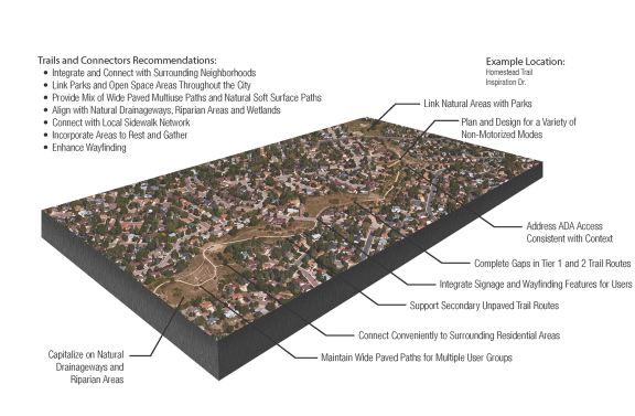
The goal of this typology is to connect parks, open space, and natural areas through a network of off-street and multiuse trails.
By providing a dedicated trail for non-motorized mobility, residents will feel more comfortable walking, picnicking, exploring nature, or just enjoying the outdoors.
- Examples: Rock Island Trail, Homestead Trail, Stetson Trail, Manitou Springs Trail, Foothills Trail, Mesa Springs Greenway, Midland Trail, Woodmen Trail, and Briargate Trail.
Complete Urban Creeks
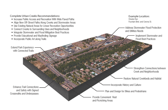
The goal of this typology is to retrofit and reinvent streams to provide multi-purpose infrastructure and non-motorized trails in more established areas of the city, and to provide walking and biking connectivity between neighborhoods, Downtown, and other significant areas.
Complete Urban Creeks incorporate non-motorized trails with streams and stormwater facilities and access to natural areas. Streams in and just outside the long established urban core have typically been constricted by development as the city grew historically. These corridors have significant potential for enhancements and redevelopment as a community, educational, transportation, or recreational focal point while integrating stormwater and flood mitigation best practices. New development and/or redevelopment should incorporate these streams as focal points with public access and trails along these corridors. This enables additional transportation options and connections by foot and bicycle. These corridors can connect us to the places where we live, work, and play. This typology provides an opportunity to make our creeks valued community places that enhance our beautiful city and provide new and different experiences along our creeks. Urban Creeks provide opportunities to view our creeks as one of our most unique and incredible assets worth maintaining for future generations.
- Examples: Fountain Creek, Monument Creek, Shooks Run, Cheyenne Creek, Camp Creek, Spring Creek, Creek Walk Trail (City of Manitou Springs), Douglas Creek, and Lower Sand Creek.
Complete Greenways
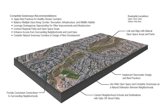
The goal of this typology is to ensure the application of multi-purpose facilities along these streams in developed and developing areas of the city in order to enhance their livability, adaptability, and further connectivity as these neighborhoods mature. This includes applying best practices that result in healthy stream corridors that integrate stormwater, infrastructure, recreation opportunities, wildlife habitat, and trail connections.
Streams in this area are typically in more residential areas with larger open spaces along the stream corridor due to the City’s flood mitigation and streamside overlay regulations. These stream corridors often incorporate trails in conjunction with maintenance access for utilities and stormwater infrastructure. These drainage corridors typically provide ample opportunity for other improvements along the stream in terms of recreation and infrastructure. Future development around streams denotes those areas that have yet to be developed in the city, most notably within Banning Lewis Ranch. These areas provide an opportunity to thoughtfully plan stormwater, recreation, and utility infrastructure along stream corridors that reflect the Majestic Landscapes vision and goals.
- Examples: Upper Sand Creek, Upper Cottonwood Creek, Kettle Creek, Pine Creek, Jimmy Camp Creek, and the Upper East Fork of Sand Creek.